
Prosper Neighbors and Block Sources
Each public source describes a different part of the block. A parcel map shows geometry. An appraisal card can name an owner and identify land. A recorded deed documents a party's role at a date. None of those sources is a complete household list. Prosper sits in both Collin and Denton counties, so the first task is to establish the anchor parcel's county rather than assuming that a Prosper mailing line selects the custodian.
| Source | What it can show about a block | Access route |
|---|---|---|
| Prosper GIS | Parcel outlines, roads, boundaries, zoning, development, and available layers | Free interactive map; approximate data; click each parcel. |
| County GIS and CAD | Parcel ID, legal description, and appraisal-card path | Free map and property search; use the county that holds the parcel. |
| County deed index | Recorded owner parties, transfers, instrument dates, and legal descriptions | Free index; image and copy access can have payment or redaction rules. |
| Voter records | Approved registration, address, precinct, and status data | Public form or request route; no public street browse. |
| EnerGov permits | Address, permit status, dates, and selected applicant or contractor fields | Prosper public search; archive scope is not stated. |
| HOA certificate search | Association identity and management certificate context | Free state search; not a resident list. |
| Town HOA resources | Board-facing meetings and a contact route | Public Town program and form. |
A historical directory can supply a dated address snapshot through UNT, TSLAC, or a library, but no complete Prosper run is verified. A permit applicant or contractor is not necessarily an owner or occupant. Likewise, a homestead exemption is an appraisal indicator, not conclusive proof that an owner lives at the parcel.
Mapping Prosper Neighbors by Parcel
The defensible neighbor method is manual and map-first. Search an anchor address in the Prosper ArcGIS Experience or county map, turn on parcel, boundary, and road layers, then zoom until the parcel lines are legible. Record the anchor's parcel ID and legal description before opening the adjoining parcels. The Town map is useful spatial context, but it is not a survey.
- Find the anchor address and note its county, parcel ID, legal description, and any GIS layer names used.
- Click each parcel that shares a boundary or frontage, then repeat for parcels across the road and at each end of the block.
- Follow each parcel ID to Collin CAD or Denton CAD for the appraisal record and mailing-versus-situs distinction.
- Use the correct county clerk's deed index to compare the legal description and recorded party history, then record the direction and relationship of each parcel.
For a whole named street rather than its immediate block, use the Prosper street directory after identifying the parcels. It covers the longer street-by-street record chain. A neighbor check should retain the map date, map URL, layer names, parcel IDs, and the date each CAD or clerk page was checked.
Prosper GIS Block Geography
Not every parcel next to an address is another private home. An edge can touch a roadway, drainage tract, common-area tract, school or utility district, commercial parcel, or a neighboring municipality. Read the parcel type and layer name in the GIS popup before describing the relationship. A visible boundary does not prove that two people are socially connected, and a parcel may be vacant or controlled by an association.
No official text page documented a one-click radius, neighbor, or adjacent-parcel export for Prosper GIS. The inspected map supports the reproducible click-by-click approach instead. If a click does not return attributes, use the Town road atlas grid, request a parcel map or public GIS export from the Town or county, and keep the request focused on the map or parcel rather than a broad request for names.
Note: A ZIP boundary is postal geography, so it cannot be used to draw the edges of a Prosper block or determine which county holds a parcel.
Checking Prosper Neighbor Parcel Cards
A parcel card can show an owner name, ownership percentage, property ID, geographic ID, mailing lines, subdivision or abstract, lot and block, legal description, situs street and ZIP, tax entities, property type, valuation fields, exemptions, and sometimes a sketch or map link. Its strongest value in a block check is the durable parcel and legal-description bridge. Mailing address and situs address can be different cities or states, so neither should be treated as a household roster.
For a Collin parcel, carry the owner and exact legal description to the Collin Official Records search. Search the owner as grantee, narrow by recorded date or document type, and compare the likely deed's lot, block, subdivision, abstract, or tract. On the Denton side, repeat that work through the Denton County Clerk Recording Division; a Collin document number does not transfer to Denton.
Owner records can lag, and public data may include statutory restrictions. A recorded deed is the better confirmation of a title connection. If the parcel is held by an entity, trust, or estate, use the recorded instrument and relevant probate or authorized-signer records rather than assuming a particular person lives nearby.
Prosper Voter Records Near a Block
Voter information is narrower than a map of the block. The public Collin Voter Registration Search asks for first name, last name, and date of birth. It has no public street-browse or ZIP filter, and the research inspection could not render its result fields. A Prosper address on the Denton side belongs with the Denton voter registrar, not the Collin form.
Collin's Election Store describes a paid full-file route that can include active and suspense voters, registration and mailing addresses, districts, and election history while excluding phone and email. The overview lists $27.06 plus a $1 convenience charge and an electronic link available for ten days. Texas does not register voters by party, ballot choices are not public through this route, and Election Code section 18.009 restricts misuse. Protected-voter and Address Confidentiality Program records are suppressed or substituted.
Prosper HOA Contact Routes
Community association information is a board-facing layer, not evidence about who lives on a block. The Town's Prosper HOA Resources program offers quarterly meetings open to Town HOA board members, a monthly e-newsletter for boards and management, a contact form, free community-room use, and speakers. Its purpose is to connect the Town with associations and management, not to publish a neighborhood household directory.
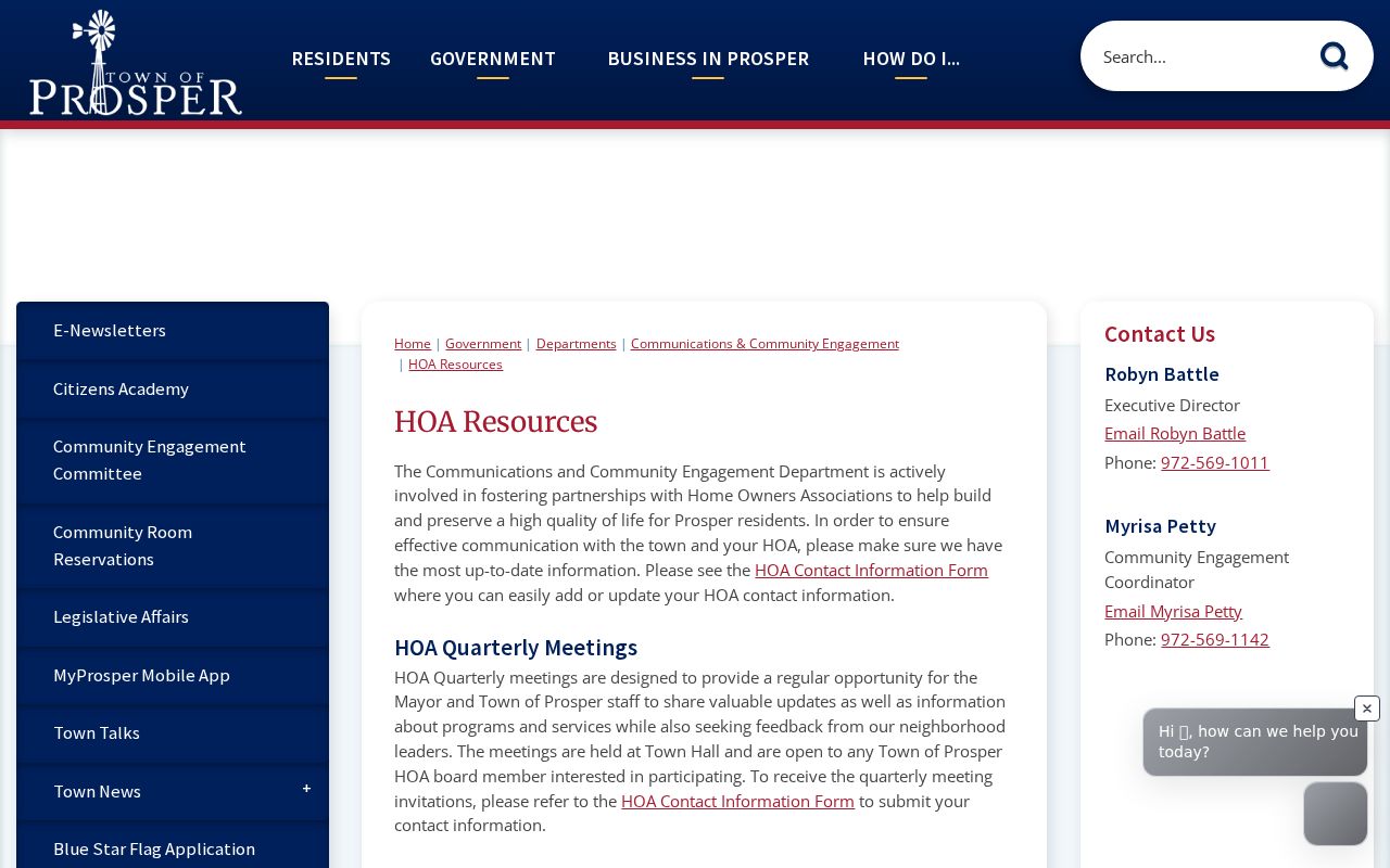
The Town page illustrates the public, board-facing route. The HOA contact-information form asks for community, management company, manager, phone, and email, and is an association contact update rather than a member directory.
Prosper HOA Resources
Myrisa Petty, 972-569-1142, mpetty@prospertx.gov, is listed as a Town contact for the board-facing program.
Community Engagement Contact
Robyn Battle, 972-569-1011, is also listed for the Town HOA resource route.
The state management-certificate search returned association names in Collin and Prosper searches, including Creekside Prosper Community Association, Twelve Oaks HOA, Dominion at Brookhollow Community Association, Tanner's Mill Owners Association, Cedar Ridge Estates Owners Association, Wandering Creek Residential Community, Prosper Lake HOA, and Trails of Prosper HOA. Check a live certificate for the association and management contact; it does not publish a resident-member roster.
Prosper Community Contact Layers
For a lawful neighborhood contact route, the Town's Town Talks program provides staff presentations for HOA, service, and community groups. The Town's resident resources also identify the Prosper Historical Society, Chamber, Rotary, Prosper Ladies Association, and arts and community groups. Their existence can help explain the local community landscape, but it does not establish current membership or a person's address.
The Prosper Community Library and Historical Society are better human-help routes for older local questions. Ask for yearbooks, microfilm, obituaries, reverse directories, local newspapers, family notebooks, or restricted materials by surname, street, county, and approximate year. Library and archive material can offer a historical lead, but significant facts still need confirmation through the relevant deed, probate, vital, or court record.
Privacy Limits for Prosper Neighbors
Public parcel and deed records do not reveal every household member, guest, utility customer, delivery recipient, DMV address, protected voter, or confidential program participant. The federal Driver's Privacy Protection Act restricts motor-vehicle personal information. Texas's Address Confidentiality Program uses a substitute mailing address for qualifying participants, and SOS guidance protects eligible voter-address fields.
Texas Penal Code sections 42.07 and 42.072 address harassment and stalking. The Texas Public Information Act does not remove confidential exceptions, and a historic scan should not be used to copy personal identifiers. If a specific public record is needed, submit a narrow, dated request to the office that actually maintains it and ask for the statutory basis if material is withheld.
Prosper Neighbor Record Checks
Official sources leave an evidence trail that can be checked again: the GIS page and layers, parcel ID, CAD card, county, legal description, deed document number, and access date. Commercial neighbor tools may combine older address associations and public-record fragments, but their results can be stale, merge same-name people, or omit protected records. Treat any such result as a lead, not a county, court, voter, or recorded land record.
| Official parcel trail | Commercial neighbor tools |
|---|---|
| Shows the custodian, parcel or document identifier, and record date for a specific fact. | May combine older sources and rarely provides a complete, current household picture. |
| Requires the correct Collin or Denton route and a check of legal description or deed. | Can merge same-name people or miss confidential records; verify with the official custodian. |
When a map result is uncertain, return to the parcel relationship first: shared boundary, frontage across the road, common area, or drainage tract. That simple description is more accurate than publishing a flat list of neighbors, and it keeps the block method tied to the documented evidence.